Latehar District, Jharkhand: Top Attractions, History, Temples, Weather & Things to Do
Latehar district occupies a significant stretch of the Chota Nagpur Plateau in Jharkhand, formed on 4 April 2001 by separating the erstwhile Latehar subdivision from Palamu district — territory that had originally become part of Palamu when that district was constituted on 1 January 1928. Despite being named among India’s 250 most backward districts and currently part of the Red Corridor, Latehar holds two of Jharkhand’s most significant natural and ecological treasures: Betla National Park, the state’s only national park and a founding member of India’s first nine tiger reserves under Project Tiger in 1974, and Netarhat, the celebrated hill station known as the “Queen of Chotanagpur.”
The district’s name itself derives from an acronym describing Betla National Park’s signature wildlife — Bison, Elephant, Tiger, Leopard, and Axis-axis (Chital deer) — while the park’s broader significance includes hosting the world’s first tiger census in 1932 and two 16th-century forts built by the Chero dynasty, still standing deep within the forest. Beyond Betla, Latehar holds Lodh Falls (Jharkhand’s highest waterfall), Lower Ghaghri Falls, the Mahuadanr Wolf Sanctuary, and Netarhat’s sweeping Eastern Ghats-style sunrise and sunset viewpoints.
Latehar District, Jharkhand — Quick Overview
| Feature | Details |
| State | Jharkhand |
| District Headquarters | Latehar town |
| District Formed | 4 April 2001 (separated from Palamu district) |
| Division | Palamu Division |
| Area | 3,660 sq km |
| Famous For | Betla National Park, Lodh Falls (Jharkhand’s highest waterfall), Netarhat hill station, Mahuadanr Wolf Sanctuary |
| Key Forts | Two 16th-century Chero dynasty forts within Betla National Park |
| Status | Part of the Red Corridor; among India’s 250 most backward districts (2006) |
| Nearest Airport | Ranchi Airport (~170-195 km from Betla) |
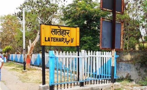
| Railway Station | Latehar Railway Station; Daltonganj; Barwadih Junction |
| Best Time to Visit | November to March (wildlife/general); November-April (extended window) |
History of Latehar District
From Palamu Subdivision to Independent District
The territory now comprising Latehar district originally became part of Palamu district when that district was formally constituted on 1 January 1928. Latehar remained a subdivision of Palamu for over seven decades before achieving full district status on 4 April 2001, when the Latehar subdivision was officially separated to form its own independent administrative unit, with Latehar town designated as the district headquarters.
The 16th-Century Chero Dynasty Forts
Deep within the forests of Betla National Park stand two historic forts built by the Chero dynasty in the 16th century. One of these forts, located approximately 400 feet near Betla village, served as the seat of the Chero King, with its main guard structure still visible high on the hill, secured by three directions and three main gates. These forts represent the most significant pre-colonial historical monuments within the district, offering a tangible connection to the region’s medieval tribal kingdom history amid the dense Chota Nagpur forest.
Betla’s Conservation Milestones
Betla National Park’s conservation history reaches back further than its formal national park status. The area was first recognised as a protected area under the Indian Forests Act in 1947, later designated a wildlife sanctuary in 1960 as an extension of Hazaribagh National Park, and became one of India’s first nine tiger reserves under Project Tiger in 1974. The park achieved full national park status in 1986 (with the core area of 232 sq km declared in September 1989). Notably, the world’s first tiger census was enumerated within this region in 1932, establishing Latehar’s significance in the global history of tiger conservation methodology.
Top Attractions in Latehar District
Betla National Park
Spanning approximately 226.32 sq km as the core area of the larger Palamu Tiger Reserve (which totals 1,129.93 sq km including buffer zones), Betla National Park is the only national park in Jharkhand and one of India’s earliest tiger reserves. The park’s name derives from the acronym of its signature wildlife: Bison, Elephant, Tiger, Leopard, and Axis-axis (Chital deer). The terrain comprises a mosaic of dry deciduous forests, plateaus, grasslands, and river valleys, with the Auranga River and smaller streams meandering through the landscape providing essential water sources for wildlife.
The park features prominent hills including Murhu, Netarhat, Huluk, and Gulgul, alongside waterfalls and natural hot springs within its boundaries. Wildlife includes tigers, elephants, leopards, gaurs (Indian bison), and various deer species, while avian fauna includes hornbill, crested-serpent eagle, forest owlets, peafowl, whistling teal, white-necked storks, pied hornbill, comb duck, and red jungle fowl — with the Kamaldah Lake serving as a particularly significant bird-attracting water body, occasionally hosting migratory species. Jeep safaris operate during morning (6-10 AM) and afternoon (2-6 PM) windows, with watchtowers and treehouses positioned strategically for wildlife observation; the park remains open from 1 October to 30 June, closing during the monsoon period (July-September).
Lodh Falls (Budha Ghagh Falls)
Located approximately 70-95 km from Betla in Mahuadanr, Lodh Falls — also known as Budha Ghagh Falls — stands at 468 feet, making it the highest waterfall in Jharkhand and one of the highest in India. The waterfall is a spectacular sight especially during the monsoon season when water flow peaks, with the cascade surrounded by dense forests that make it a perfect destination for nature lovers, photographers, and adventure seekers.
Netarhat — Queen of Chotanagpur
Approximately 100 km from Betla, Netarhat is celebrated as the “Queen of Chotanagpur,” a popular hill station whose name translates to “Nature’s Heart.” Drawing tourists from across India and abroad, Netarhat offers stunning sunrise and sunset views that rank among the most celebrated in eastern India, making it one of the district’s most essential scenic destinations.
Lower Ghaghri Falls
Located near Netarhat, Lower Ghaghri Falls (also referred to as Upper Ghaghri Falls in some sources) is a picturesque waterfall perfect for nature lovers, complementing the broader Netarhat hill station experience with another significant cascading water feature within easy reach.
Palamau Forts (Chero Dynasty)
The two ancient forts within Betla National Park — both built by the Chero dynasty in the 16th century — add genuine historical significance to the park’s wildlife-focused tourism. One fort is situated on a hilltop with commanding views, while the other lies in ruins amid the surrounding forest, together offering visitors a glimpse into the region’s pre-colonial tribal kingdom history.
Suga Bandh Hot Springs
Located near Betla National Park, the Suga Bandh Hot Springs are a popular attraction for visitors seeking relaxation amid the park’s natural surroundings, adding a wellness dimension to the broader wildlife and historical tourism circuit.
Mahuadanr Wolf Sanctuary
A dedicated wildlife sanctuary within Latehar district, the Mahuadanr Wolf Sanctuary provides essential habitat for wolves and other regional wildlife, representing a focused conservation effort distinct from the broader biodiversity protection found at Betla National Park.
Koel River and Falls
The Koel River, along with its tributaries, flows through Betla National Park, creating scenic waterfalls particularly during the monsoon season, adding to the park’s diverse water-feature landscape beyond the more famous Lodh Falls.
Weather in Latehar District
November to March — Best Time: Pleasant, cool, and dry conditions make this the ideal period for wildlife safaris at Betla National Park, when animals are more visible due to thinner forest leaf cover, and for general sightseeing across the district’s waterfalls and hill stations.
April to June — Summer (Wildlife Viewing Peak): While hot and dry, this period is considered the peak time for wildlife sightings within the park, as animals congregate more visibly around water sources when forest leaves are sparse.
July to September — Monsoon (Park Closure): Betla National Park closes entirely during this period (1 July to 30 September), though the monsoon brings dramatic full-flow conditions to Lodh Falls and the district’s other waterfalls, best appreciated from outside the park’s protected core zones.
Things to Do in Latehar District (2026)
Jeep Safari at Betla National Park — Book an early morning or late evening safari for the best chance of spotting tigers, elephants, leopards, and gaurs within their natural habitat.
Explore the 16th-Century Chero Forts — Visit both the hilltop and ruined forest forts within Betla National Park for genuine medieval tribal kingdom heritage.
Trek to Lodh Falls — Time a monsoon-season visit to witness Jharkhand’s highest waterfall at its most dramatic, full-flow state.
Sunrise and Sunset at Netarhat — Spend an evening and morning at the “Queen of Chotanagpur” for views consistently rated among eastern India’s finest.
Birdwatch at Kamaldah Lake — Within Betla National Park, watch for hornbills, crested-serpent eagles, and migratory waterfowl at this significant birding location.
Relax at Suga Bandh Hot Springs — Combine wildlife safaris with a restorative soak near the park’s natural hot spring.
How to Reach Latehar District
By Air: Ranchi Airport is the nearest, approximately 170-195 km from Betla National Park, with daily flights connecting to all major Indian cities.
By Train: Latehar Railway Station and Daltonganj Railway Station serve as the nearest rail connections, with Barwadih Junction also providing access; trains from Ranchi, Patna, Delhi, Kanpur, Lucknow, and Mughalsarai connect frequently to these stations.
By Road: Betla National Park is accessible from Ranchi via Latehar (170 km) on NH-75, from Daltonganj via Dubiakhanr (25 km) on NH-75, and from Patna via Aurangabad (260 km) on NH-98 and NH-75, with regular state-run buses and private taxis operating throughout.
Conclusion
Latehar district delivers Jharkhand’s most significant wildlife and natural heritage combination — Betla National Park’s tiger reserve legacy dating to 1974 (with conservation roots reaching back to 1947), two 16th-century Chero dynasty forts hidden within dense forest, Jharkhand’s highest waterfall at Lodh Falls, and Netarhat’s celebrated “Queen of Chotanagpur” sunrise vistas. For travellers seeking authentic Chota Nagpur Plateau wilderness combined with genuine medieval tribal history, Latehar offers one of eastern India’s most rewarding and still relatively undiscovered destinations.
FAQs About Latehar District, Jharkhand
Q1. What is Latehar district famous for?
A: Latehar is famous for Betla National Park (Jharkhand’s only national park and one of India’s first tiger reserves under Project Tiger), Lodh Falls (Jharkhand’s highest waterfall at 468 feet), Netarhat hill station (“Queen of Chotanagpur”), and the Mahuadanr Wolf Sanctuary.
Q2. What does the name “Betla” mean?
A: “Betla” is an acronym derived from the park’s signature wildlife species: Bison, Elephant, Tiger, Leopard, and Axis-axis (Chital deer), reflecting the rich biodiversity that defines this Chota Nagpur Plateau national park.
Q3. What historical significance do the Chero dynasty forts hold within Betla National Park?
A: Two forts built by the Chero dynasty in the 16th century stand within Betla National Park, with one located on a hilltop and the other in ruins amid the forest. One fort, situated approximately 400 feet near Betla village, served as the seat of the Chero King, offering visitors a tangible connection to the region’s medieval tribal kingdom history.
Q4. When was Betla National Park first recognised for conservation, and what tiger conservation milestones does it hold?
A: Betla’s conservation history began in 1947 under the Indian Forests Act, followed by wildlife sanctuary status in 1960. It became one of India’s first nine tiger reserves under Project Tiger in 1974 and achieved full national park status in 1986. Notably, the world’s first tiger census was conducted in this region in 1932, marking its global significance in tiger conservation history.
Q5. When is the best time to visit Latehar district, particularly for wildlife safaris?
A: November to March offers the most pleasant, comfortable weather for general sightseeing and wildlife safaris at Betla National Park. April to June, despite the heat, is considered peak wildlife-viewing season since animals congregate more visibly around water sources when forest leaf cover is sparse. The park closes entirely from July to September during monsoon season.