West Kameng District, Arunachal Pradesh: Top Attractions, History, Temples, Weather & Things to Do
West Kameng district occupies a strategically and culturally significant stretch of the eastern Himalayas in Arunachal Pradesh, sharing international borders with Tibet to the north and Bhutan to the west, with Tawang district to the northwest and East Kameng to the east. The district takes its name from the Kameng River, a tributary of the Brahmaputra that flows through this mountainous terrain, historically controlled at various points by the Mon kingdom, Bhutan, Tibet, and the Ahom kingdom.
Tibetan Buddhism gained a strong foothold among West Kameng’s tribal groups as early as the 7th century, when the Kachen Lama constructed the Lhagyala Gompa at Morshing — one of the earliest markers of the Mahayana Buddhist tradition that continues to define the district’s spiritual identity today. With Bomdila as its headquarters, West Kameng serves as the primary gateway for travellers heading toward Tawang, offering its own understated but genuine appeal: terraced hillsides, century-old monasteries, apple orchards, hot springs, and a 1962 Indo-China War memorial that commemorates one of modern India’s most significant border conflicts.
West Kameng District, Arunachal Pradesh — Quick Overview
| Feature | Details |
| State | Arunachal Pradesh |
| District Headquarters | Bomdila (~2,217-2,530m elevation) |
| Area | 8.86% of Arunachal Pradesh’s total area |
| Name Origin | Kameng River, a tributary of the Brahmaputra |
| Borders | Tibet (N); Bhutan (W); Tawang district (NW); East Kameng district (E); Sonitpur & Udalguri districts, Assam (S) |
| Highest Peak | Kangto (also state’s highest peak) |
| Highest Point | Sela Pass — 13,714 feet |
| Famous For | Bomdila Monastery (GRL), Dirang Dzong, Eaglenest Wildlife Sanctuary, Sangti Valley, Sela Pass |
| Major Tribes | Monpa, Sherdukpen, Aka (Hrusso), Miji (Sajalong), Khawa (Bugun) |
| Nearest Airport | Tezpur Airport, Assam (~160 km) |
| Nearest Railway | Rangapara North Station (~95 km) |
| Best Time to Visit | March-April (spring) and October-November (autumn) |
| Winter | Snowfall mid-November to February (Khupi, Bomdila, Sela) |
History of West Kameng District
1. Ancient and Medieval Rule — Mon Kingdom to Ahom Influence
The area around the Kameng river has traditionally come under the control of the Mon kingdom, Bhutan, Tibet, and the Ahom kingdom across different historical periods. Tibetan Buddhism established a strong foothold among the tribal groups as early as the 7th century CE, with the Kachen Lama constructing the Lhagyala Gompa in Morshing — one of the region’s earliest documented Buddhist religious structures, situated on the mountainside overlooking the Morshing valley, approximately 80 km from Bomdila.
2. Feudal Chiefdoms — Miji and Aka Control
Whenever loose central control was exerted over the area, small feudal chiefdoms ruled by Miji and Aka chiefs dominated local governance. Evidence of this period survives in ruined fortresses such as those in Bhalukpong, constructed between the 10th and 12th centuries, and the Dirang Fort, built in the 17th century specifically to defend against invasions from neighbouring chiefdoms.
3. Thembang — A Royal Lineage Reaching to 1100 BCE
Thembang village, located approximately 55 km northeast of Bomdila at an altitude of about 2,169-2,300 metres, holds extraordinary historical significance. In the medieval era, Thembang served as the headquarters of a large territory ruled by the powerful Thembang Bapu, direct descendants of the king of Tibet. This is one of the oldest villages in the region, having witnessed many wars — resulting in strong fortification with two stone wall gates (northern and southern). The Thembang Dzong is believed to have been constructed as early as 1100 BCE, with archaeological findings including Neolithic tools and weapons, and is currently a protected archaeological monument under the Archaeological Section, Research Department, Government of Arunachal Pradesh.
4. British Colonial Period and Administrative Naming
Upon the arrival of the British, present-day West Kameng was placed under the North-East Frontier Agency, renamed the Balipara Frontier Tract in 1919 with headquarters at Charduar, Assam. In 1946, the district area was carved out as the Sela Sub-Agency, still headquartered at Charduar. Following Indian independence, this was renamed the Kameng Frontier Division, with its headquarters later transferred to Bomdila in 1954.
5. Tibetan Refugees and the 1962 Indo-China War
With China’s invasion of Tibet in 1950, Tibetan refugees began populating the area, adding another layer to the district’s already complex cultural fabric. The 1962 Sino-Indian War brought devastating consequences — the invasion of Chinese troops into this region resulted in many historical monuments being either destroyed or defaced. Following this conflict, the Kameng Frontier Division was renamed the Kameng District, with the Political Officer redesignated as the Deputy Commissioner. The Bomdila War Memorial, inaugurated in 1993 on the town’s highest point, commemorates the supreme sacrifice made by the 1 Sikh Li troops of the Indian Army during this conflict, who fought against Chinese forces with limited weaponry — original bunkers from the period remain maintained by the Indian Army today.
Top Attractions in West Kameng District
1. Bomdila Monastery (GRL Monastery)
Perched atop a scenic hill in Bomdila, the GRL Monastery (Gentse Gaden Rabgyal Ling), popularly known as Bomdila Monastery, was established in 1965-66 by the 12th reincarnate of Tsona Gontse Rinpoche and is inspired by the Tsona Gontse Monastery of South Tibet, dating to the 15th century. The monastery represents one of the major centres of the Lamaistic faith of Mahayana Buddhism in the region and is divided into three sections: the Upper Gompa (the main monastery, housing a Buddha temple, prayer hall, and school for young monks), the Middle Gompa (one of the oldest sections, housing the revered Blue Medicine Buddha believed to have healing powers), and the Lower Gompa (located at the centre of Bomdila’s main market, featuring a spacious prayer hall and prominent Tibetan architectural influence). The main prayer hall renovation was dedicated to the service of God by His Holiness the 14th Dalai Lama on 13 October 1997.
2. Dirang Dzong Fort
Located in Dirang, situated at approximately 1,500 metres in a valley cut by the Dirang Chu river, 42 km before Bomdila on the Tawang road, Dirang Dzong is a representation of Monpa culture. Built in 1831 CE, this fort served as the centre of all administrative activities of the Monpas during its operational era, set atop a hilltop in a four-storied stone building with a distinctively designed wooden gate reflecting local architectural patterns. Though the fort is now in ruins, these remains stand as proof of the architectural excellence of the era.
3. Sangti Valley
Located approximately 10-14 km south of Dirang, Sangti Valley is among the best spots in Arunachal Pradesh for birdwatching, particularly celebrated for the seasonal presence of the endangered Black-necked Crane, which migrates from Tibet to winter here between November and February. The valley also features kiwi orchards and yak farms, and its wooded hillsides and magnificent valleys see far fewer visitors than most listed tourist spots, offering a genuinely tranquil escape.
4. Sela Pass
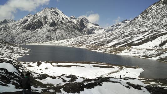
Situated at 13,714 feet, Sela Pass is the main road crossing between the Kameng districts and Tawang, and one of the highest all-weather motorable passes in the world, remaining snowbound for much of the year. The Border Roads Organisation maintains the route through winter, though snowfall can cause delays. Strategically, Sela Pass carries deep historical significance from the 1962 war, when Indian troops held positions here. Sela Lake, just off the highway, is a shallow glacial lake that freezes completely in winter and thaws by April into a still grey mirror.
5. Eaglenest Wildlife Sanctuary
Established in West Kameng in 1989 with an area of 217 sq km, Eaglenest Wildlife Sanctuary spans altitudes from 500 to over 3,200 metres, creating habitats ranging from lush tropical forests to alpine meadows. The sanctuary is a paradise for birdwatchers, home to over 450 bird species including the rare Bugun Liocichla — a species discovered relatively recently and named after the Bugun tribal community. Beyond birdwatching, guided nature treks through dense forests offer chances to spot red pandas, Bengal tigers, Asiatic black bears, and elephants.
6. Chilipam Monastery (Zangdokpalri Monastery)
Officially named Sangngag Choekhor Dargyeling, popularly known as Chilipam Monastery, this hilltop monastery near Rupa is over 200 years old and stands as a significant centre of Tibetan Buddhism in West Kameng. The serene monastery is known for its traditional Tibetan architectural style, vibrant murals, and colourful depictions of Buddhist teachings, with the location offering stunning 280-degree views of the lower valleys. Visitors can purchase traditional incense crafted by the monks from natural resins, herbs, and aromatic woods.
7. Tipi Orchid Research and Development Centre
Located at Tipi, approximately 65 km from Tezpur on the banks of the Bharali river, this glass house orchidarium displays over 500 to 7,500 varieties of colourful orchids (depending on the source), including rare and endangered species. Established by the Department of Environment and Forest, Government of Arunachal Pradesh, the centre serves as both a conservation facility and a research hub for orchid species development.
8. Bomdila War Memorial and R.R. Hill
Inaugurated in 1993 at Bomdila’s highest point, the War Memorial commemorates the supreme sacrifice of the 1 Sikh Li troops during the 1962 Indo-China War. Nearby R.R. Hill offers magnificent views of snow-covered Himalayan ranges and the road leading toward Tawang and Bhutan’s border — a must-visit for both history and scenery.
9. Thembang Heritage Village
A protected archaeological monument 55 km northeast of Bomdila at 2,169-2,300 metres, Thembang Dzong’s wood and stone architecture reflects strong Tibetan and Bhutanese influence, with the believed construction dating as early as 1100 BCE, supported by Neolithic tool findings.
Temples and Monasteries of West Kameng District
| Site | Location | Tradition | Key Feature |
| Bomdila Monastery (GRL) | Bomdila | Mahayana Buddhism (Gelug school) | Three-section Gompa; visit by 14th Dalai Lama 1997 |
| Lhagyala Gompa | Morshing | Mahayana Buddhism | 7th-century origins; built by Kachen Lama |
| Chilipam Monastery | Near Rupa | Tibetan Buddhism | 200+ years old; 280-degree valley views |
| Dirang Dzong | Dirang | Monpa cultural-religious centre | 1831 CE; administrative and spiritual hub |
| Rupa Monastery | 15 km from Rupa village | Tibetan Buddhism | Built on promontory; 270-degree views |
| Thembang Dzong | Thembang village | Monpa ancient royal seat | Construction dated to ~1100 BCE |
Weather in West Kameng District
March to April (Spring) and October to November (Autumn) — Best Time: Pleasant weather with clear skies and comfortable temperatures, ideal for trekking, exploring monasteries, and soaking in breathtaking landscapes. Apple, peach, walnut, and kiwi orchards are at their best in October when harvest season brings colour and commerce to local markets.
Mid-November to February — Winter/Snowfall: Snow falls across the district, particularly visible at Khupi, Bomdila, and Sela Pass, which remains snowbound for much of the year. Black-necked Cranes winter in Sangti Valley during this exact period (November-February), making it an excellent dual-purpose season for snow scenery and rare bird sightings.
June to September — Monsoon: The district experiences significant rainfall typical of the eastern Himalayas; road conditions on routes like Sela Pass can be affected, though the BRO maintains year-round access.
Things to Do in West Kameng District (2026)
Explore Bomdila Monastery’s Three Gompas — Visit the Upper, Middle, and Lower Gompas in sequence, paying particular attention to the Blue Medicine Buddha at Middle Gompa and the Tibetan architecture at Lower Gompa.
Birdwatch in Sangti Valley — Time a November-February visit to witness the endangered Black-necked Crane’s seasonal migration alongside the valley’s kiwi orchards and yak farms.
Cross Sela Pass — Experience one of the world’s highest all-weather motorable passes, combined with the glacial Sela Lake and reflections on the 1962 war history.
Trek Eaglenest Wildlife Sanctuary — Arrange a guided nature trek across this 217 sq km sanctuary’s varied altitude habitats, watching for the rare Bugun Liocichla and other endemic bird species.
Visit Dirang’s Hot Springs and Dzong — Combine the functional sulphurous hot springs near Dirang Chu with the historic 1831 Dzong fort for a complete cultural-relaxation day.
Thembang Heritage Trek — Explore this protected archaeological village dating possibly to 1100 BCE, with its distinctive stone-gated fortification and Tibetan-Bhutanese architectural influence.
How to Reach West Kameng District
By Air: Tezpur Airport, Assam, is the nearest airport, approximately 160 km from Bomdila, with taxis and shared vehicles available for onward travel.
By Train: Rangapara North Railway Station is the nearest major railhead, approximately 95 km from Bomdila, well connected to Guwahati and other major Assam cities.
By Road: Bomdila is well connected via NH-13 (Trans-Arunachal Highway), approximately 160 km from Tezpur and 340 km from Guwahati. Regular buses and shared sumos operate from Tezpur, Balipara, and Guwahati.
Conclusion
West Kameng district serves the eastern Himalayas’ dual identity as both a serene Buddhist cultural landscape and a strategically vital border region — home to a 7th-century monastery lineage, a fortified village potentially dating to 1100 BCE, the Black-necked Crane’s winter migration ground, and one of the world’s highest motorable passes carrying the weight of 1962 war history. For travellers en route to Tawang or seeking the eastern Himalayas’ understated charm, West Kameng delivers terraced hillsides, century-old Gompas, and Monpa, Sherdukpen, and Aka tribal culture in a genuinely rewarding, less-trafficked corridor.
FAQs About West Kameng District, Arunachal Pradesh
Q1. What is West Kameng district famous for?
A: West Kameng is famous for Bomdila Monastery (GRL Monastery), Dirang Dzong Fort, Sela Pass (one of the highest motorable passes in the world), Eaglenest Wildlife Sanctuary (home to the rare Bugun Liocichla bird), Sangti Valley’s Black-necked Crane migration, and the ancient Thembang Heritage Village.
Q2. How did West Kameng district get its name?
A: The district is named after the Kameng River, a tributary of the Brahmaputra that flows through the region. The area has historically come under the control of the Mon kingdom, Bhutan, Tibet, and the Ahom kingdom at various points.
Q3. What is the historical significance of Thembang village?
A: Thembang, located 55 km northeast of Bomdila, was historically the headquarters of a large territory ruled by the Thembang Bapu, direct descendants of the king of Tibet. The Thembang Dzong is believed to have been constructed as early as 1100 BCE, supported by archaeological findings of Neolithic tools and weapons, and is now a protected archaeological monument.
Q4. What happened in West Kameng during the 1962 Indo-China War?
A: During the 1962 Sino-Indian War, Chinese troops invaded the region, destroying or defacing many historical monuments. The 1 Sikh Li troops of the Indian Army made significant sacrifices defending positions including Sela Pass. The Bomdila War Memorial, inaugurated in 1993, commemorates these soldiers, and original bunkers from the period remain maintained by the Indian Army.
Q5. When is the best time to visit West Kameng district?
A: March-April (spring) and October-November (autumn) offer the most pleasant weather with clear skies, ideal for trekking and monastery visits. Winter (mid-November to February) brings snowfall to higher elevations like Sela Pass and coincides with the Black-necked Crane’s migration to Sangti Valley, making it a special dual-purpose season for snow and birdwatching enthusiasts.