Karimganj District, Assam: Top Attractions, History, Temples, Weather & Things to Do
Karimganj district occupies the southernmost stretch of Assam’s Barak Valley, sharing an international border with Bangladesh where the Kushiara River flows as a natural boundary between the two countries. Originally a subdivision of Sylhet district under British India, Karimganj was severed from Sylhet during the Partition of India and included in Assam as part of the undivided Cachar district before finally becoming its own independent district in 1983, with Karimganj Town designated as the headquarters. Sandwiched between the Chhatachura, Adamail, and Duhalia hill ranges, and threaded through by three major rivers — Kushiara, Longai, and Singla — Karimganj offers a quiet, largely undiscovered corner of Northeast India defined by tea gardens, wetlands, and a layered colonial and pre-colonial history.
The district’s most distinctive natural feature is Son Beel, the second-largest seasonal wetland in Asia and the largest wetland in Assam, which transforms remarkably between seasons — functioning as rice farmland through winter until the end of March, then filling with water during the monsoon to become a full lake. Beyond this ecological marvel, Karimganj carries traces of the Koch dynasty, the kingdom of Khaspur, and a poignant 1857 Sepoy Mutiny battlefield at Malegarh, alongside the historic Kachakanti Devi Temple and the British-built Badarpur Fort.

Karimganj District, Assam — Quick Overview
| Feature | Details |
| State | Assam |
| Region | Barak Valley |
| District Headquarters | Karimganj Town |
| District Formed | 1983 (from undivided Cachar district) |
| International Border | Bangladesh (via Kushiara River) |
| Famous For | Son Beel (2nd-largest seasonal wetland in Asia), Badarpur Fort, Kachakanti Devi Temple, Chhatachura Range |
| Key Rivers | Kushiara, Longai, Singla, Barak |
| Hill Ranges | Chhatachura, Adamail (Patharia), Duhalia (Pratapgarh) |
| Distance from Guwahati | ~313 km |
| Nearest Airport | Kumbhirgram Airport, Silchar (~85 km) |
| Railway Station | Karimganj Junction; Badarpur Junction (~32 km, main Barak Valley railhead) |
| Best Time to Visit | October to February/March |
| Summer Temperature | Up to 30-32°C (March-June) |
History of Karimganj District
1. Tripura, Koch Dynasty, and the Kingdom of Khaspur
Karimganj’s pre-colonial history traces through a succession of regional powers. The area was originally a part of the kingdom of Tripura before being taken over by the Koch dynasty. Following the demise of the last ruler of the Koch dynasty in this region, the territory declared its independence, giving rise to the kingdom of Khaspur — a distinctive local political entity that emerged from this dynastic transition before the British colonial era began to assert influence over the Barak Valley.
2. From Sylhet District to Assam’s Barak Valley
Karimganj Town became a subdivision of Sylhet district of British India in the late 19th century. During the Partition of India in 1947, the region was severed from Sylhet (which became part of East Pakistan, later Bangladesh) and was included in India as part of Cachar district in Assam. This partition-era border redrawing left Karimganj with its present geography — directly abutting Bangladesh, with the Kushiara River serving as the international boundary separating Assam from its neighbouring country. In 1983, Karimganj achieved full district status, separating from Cachar with its headquarters established at Karimganj Town.
3. The 1857 Sepoy Mutiny and Malegarh
Malegarh Crematorium stands as a solemn historical reminder of the 1857 Indian Rebellion (Sepoy Mutiny), serving as the site where more than 50 brave soldiers who lost their lives during the revolt were cremated. The location served as a battlefield during this critical chapter of India’s resistance to British colonial rule, with the site’s historical weight reflecting the Barak Valley’s broader involvement in the 1857 uprising against East India Company authority.
4. Badarpur Fort — Mughal-Era Origins
The Badarpur Fort, located on the banks of the Barak River, was originally built during the Mughal era when the region was part of the Sylhet district — territory now located in present-day northeast Bangladesh. The fort has since been restored multiple times over the years, with most of its structure now in ruins, though massive restoration work continues to attract more tourists to this historically layered site.
Top Attractions in Karimganj District
1. Son Beel
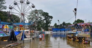
Recognised as the second-largest seasonal wetland in Asia and the largest wetland in the state of Assam, Son Beel presents one of the most ecologically fascinating phenomena in Northeast India. During the winter season through the end of March, the wetland transforms into farmland used for rice cultivation. As the rainy season arrives, the area fills with water and becomes a lake — its shallow depth causing it to overflow during heavy rains, with the excess water flowing into the Kushiara River via the Kakra River before continuing on toward Bangladesh. The wetland is home to numerous Hizol trees that create a wonderful scenic backdrop around the lake, making Son Beel a haven for birdwatchers and nature photographers alike.
2. Badarpur Fort
Situated on the picturesque banks of the Barak River, Badarpur Fort offers visitors a tangible connection to the Mughal era and the broader Sylhet-Assam colonial history. The entry to the fort is through its main gate, which still stands despite the surrounding structure being largely in ruins. Spread across a wide area, the fort’s riverside setting makes it one of the most visually rewarding heritage sites in the district, with ongoing restoration efforts aimed at preserving its historical significance for future visitors.
3. Chhatachura Range
Forming the district’s eastern border with Hailakandi District, the Chhatachura Range originates from Karimganj’s southeastern border and extends approximately 50 miles from north to south, with a breadth reaching up to 13 miles in certain areas. Chhatachura Peak, at 2,087 feet, is the range’s highest point, while Saraspur forms the middle section at 1,000 feet near the Barak River, and the lowest section — known as the Badarpur hills — averages around 500 feet. This dramatic elevation range makes the Chhatachura area one of the district’s premier destinations for trekking, nature trails, and capturing scenic photography.
4. Kachakanti Devi Temple (Sri Kancha Kanti Devi Temple)
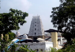
Located approximately 60 km from Karimganj town, the Kachakanti Devi Temple is one of the most famous and revered temples in the district, dedicated to a powerful local deity believed to be a fused representation of Goddess Kali and Goddess Durga. Local devotees hold deep faith in this strong local goddess tradition, making the temple a significant regional pilgrimage destination that draws worshippers from across the Barak Valley.
5. Malegarh Crematorium
A historically poignant site connected to the 1857 Sepoy Mutiny, Malegarh Crematorium honours over 50 soldiers who lost their lives during the rebellion and were cremated at this location, which served as an active battlefield during the uprising. The site offers visitors a sombre but historically essential stop for understanding the Barak Valley’s role in India’s broader struggle against colonial rule.
6. Duhalia Range (Pratapgarh Range)
The third major hill range passing through Karimganj district, Duhalia separates the valleys of Longai and Chargola, and is popularly referred to as the Pratapgarh Range. Its highest hill reaches approximately 1,500 feet above sea level, offering further trekking and nature exploration opportunities within the district’s varied topography.
7. Adamail Range (Patharia Range)
Forming the western border of Karimganj district with Bangladesh, the Adamail Range — also called the Patharia Range — extends across approximately 45 km, with its highest peak reaching about 800 feet above sea level. This range adds to the district’s collection of forested hill systems ideal for nature walks and birdwatching.
8. Tea Gardens
Located approximately 15 km from Karimganj town, the district’s scenic tea estates offer visitors a refreshing escape surrounded by lush greenery, with opportunities to experience tea plantation life firsthand and purchase locally produced tea. These gardens reflect Karimganj’s broader economic identity as an agriculturally significant district within Assam.
Temples and Religious Sites of Karimganj District
| Site | Location | Deity/Tradition | Key Feature |
| Kachakanti Devi Temple | ~60 km from Karimganj town | Goddess Kancha Kanti (Kali-Durga fusion) | Strong local deity tradition; major regional pilgrimage |
| Malegarh Crematorium | Karimganj district | 1857 Sepoy Mutiny memorial | Historic battlefield and cremation site |
Weather in Karimganj District
October to February/March — Best Time: Pleasant, cool temperatures ranging 10°C-25°C make this the ideal window for sightseeing, trekking, and outdoor exploration of the district’s wetlands, hills, and historical sites.
March to June — Summer: Hot and uncomfortable conditions, with temperatures rising above 30-32°C, making extended outdoor activities less comfortable, though it remains a viable option for travellers preferring fewer crowds.
June to September — Monsoon: Heavy rainfall is common, transforming Son Beel from farmland into a full seasonal lake and adding to the district’s lush green landscapes, though travel disruptions are possible and generally not recommended for sightseeing purposes.
Things to Do in Karimganj District (2026)
Birdwatch at Son Beel — Time a winter or early monsoon visit to witness the wetland’s seasonal transformation between farmland and lake, observing the diverse birdlife around the Hizol tree-lined banks.
Explore Badarpur Fort’s Riverside Ruins — Walk through the historic Mughal-era fort on the banks of the Barak River, examining its surviving main gate and ongoing restoration work.
Trek the Chhatachura Range — Climb to Chhatachura Peak at 2,087 feet for panoramic views, or explore the gentler Saraspur and Badarpur hill sections for varied trekking experiences.
Pilgrimage to Kachakanti Devi Temple — Visit this revered local goddess shrine, particularly meaningful for those interested in the syncretic Kali-Durga devotional tradition unique to the Barak Valley region.
Riverside Walks and Picnics — Enjoy quiet walks along the Kushiara and Barak riverbanks, taking in views toward the Bangladesh border and the district’s characteristic tranquil, undeveloped charm.
Visit Local Tea Gardens — Experience tea plantation life and purchase fresh, locally produced tea approximately 15 km from Karimganj town.
How to Reach Karimganj District
By Air: Kumbhirgram Airport in Silchar is the nearest, approximately 85 km from Karimganj; there is no direct flight connectivity to Karimganj itself.
By Train: Karimganj Junction and Badarpur Junction (approximately 32 km away) serve as the district’s main railway connections, with Badarpur functioning as the principal railhead for the entire Barak Valley and southern Assam region, connected via the Lumding-Silchar railway line to Guwahati, Kolkata, and Delhi.
By Road: National Highways 6 and 37 pass through Karimganj, connecting it to Silchar (32 km away), Imphal, and Shillong, with regular bus and taxi services available for both intercity and local travel.
Conclusion
Karimganj district rewards travellers seeking genuine offbeat tranquility in Northeast India — a Bangladesh border town where the Kushiara River marks the international boundary, where Son Beel’s seasonal wetland-to-farmland transformation ranks among Asia’s most fascinating ecological phenomena, and where layered history spans the Koch dynasty, the kingdom of Khaspur, Mughal-era fortification, and the 1857 Sepoy Mutiny. For visitors willing to venture beyond Assam’s more established Kaziranga and Guwahati circuits, Karimganj delivers an authentic, peaceful glimpse into the Barak Valley’s distinctive natural and historical fabric.
FAQs About Karimganj District, Assam
Q1. What is Karimganj district famous for?
A: Karimganj is famous for Son Beel — the second-largest seasonal wetland in Asia and the largest wetland in Assam — alongside Badarpur Fort, the Kachakanti Devi Temple, the Chhatachura hill range, and its location directly bordering Bangladesh via the Kushiara River.
Q2. What is unique about Son Beel?
A: Son Beel undergoes a remarkable seasonal transformation: during winter through the end of March, it functions as farmland used for rice cultivation. As the monsoon arrives, the area fills with water and becomes a full lake, with its shallow depth causing overflow into the Kushiara River via the Kakra River, eventually flowing toward Bangladesh.
Q3. When did Karimganj become an independent district of Assam?
A: Karimganj became a subdivision of Sylhet district under British India in the late 19th century, was severed from Sylhet during the 1947 Partition of India and included in Cachar district, and finally achieved full independent district status in 1983, with Karimganj Town as its headquarters.
Q4. What historical connection does Karimganj have to the 1857 Sepoy Mutiny?
A: Malegarh Crematorium in Karimganj district served as a battlefield during the 1857 Indian Rebellion (Sepoy Mutiny), and over 50 soldiers who lost their lives during the revolt were cremated at this site, making it an important historical memorial connected to this critical chapter of India’s resistance against British colonial rule.
Q5. When is the best time to visit Karimganj district?
A: October to February (or March) offers the most pleasant weather, with cool temperatures ranging from 10°C to 25°C, ideal for sightseeing, trekking, and exploring Son Beel and the district’s hill ranges. Summer (March-June) brings uncomfortable heat above 30°C, while the monsoon (June-September) brings heavy rainfall best suited for travellers specifically wanting to see the wetland at its fullest.